A study by scientists at the Indian Space Research Organisation (ISRO) has identified an under-recognised hazard in snow-bound areas as the reason for the flash flood that devastated parts of Uttarkashi in August last year.
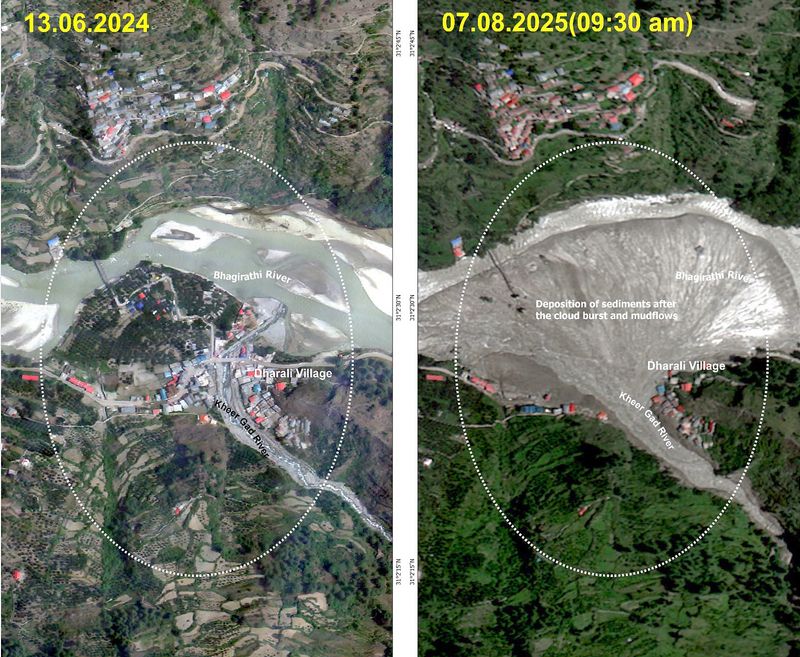
The flash flood at Dharali in the Uttarkashi region of the Central Himalayas, which caused extensive damage and loss of life, was triggered by the rapid collapse of an exposed ice patch within the nivation zone of the Srikanta Glacier, the study found.
Nivation zones are glacial areas in high mountains subjected to seasonal freezing, thawing, and melt-water movement, which break down rocks and move debris, often forming steep-walled, bowl-like basins due to erosion.
“Conservative estimates of ice volume, gravitational potential energy and melt-water yield, combined with steep longitudinal gradients and channel confinement, explain the short-duration, high-intensity debris-laden surge that produced severe downstream impacts. These findings identify ice-patch collapse in the nivation zones as an under-recognised cryospheric hazard,” the researchers said.
The study, undertaken by five experts based at different remote sensing centres of ISRO, has been published in Springer’s Natural Hazards, an international peer-reviewed journal, on February 28.
According to the study, integration of high-resolution digital elevation models, multi-temporal satellite imagery and publicly available video records enabled reconstruction of the event chronology and ridge-to-valley hazard propagation.
Pre-event imagery during the ablation period revealed exposed ice patches on steep north- to northeast-facing slopes, indicating thinning seasonal snow and firn cover consistent with ongoing deglaciation, while post-event observations confirmed complete ice-patch disappearance and the formation of fresh downslope erosional scars, the researchers found.
Pointing out that the Himalayas hosts extensive glaciers, seasonal snow and peri-glacial ice that regulate major Asian river basins, the researchers said that within this vast cryospheric system, the Garhwal Himalayas, located in the northwestern part of Uttarakhand, forms a segment of the Central Himalaya that is characterised by complex geological and glaciological settings.
“While glaciers in this region were relatively stable in the past, recent satellite and field based observations indicate accelerated thinning and mass loss extending from glacier termini to high-altitude zones above 5,200 meters,” the researchers said.
“Both debris-mantled ice areas with ice cliffs and surface ponds, as well as clean-ice accumulation zones have transitioned from relative stability to substantial thinning, reflecting a broader trend of glacier imbalance and ongoing deglaciation across the Central Himalayas, although monitoring remains constrained by temporal resolution and field accessibility,” they observed.
Referring to recent studies which indicate that the region is experiencing pronounced warming and more frequent extreme meteorological events, including extreme rainfall, snow hazards, flash floods and glacier-related processes, they cautioned that these widespread cryospheric changes have important implications for mountain hazard dynamics as de-glaciation can destabilise high-altitude slopes and promote cascading cryo-hydrological processes with downstream consequences.